|
||||||||||||||||||||||||||||||||
 |
||||||||||||||||||||||||||||||||
|
|
|
|||||||||||||||||||||||||||||||
|
|
|
|
|||||||||||||||||||||||||||||
|
|
|
|
||||||||||||||||||||||||||||||
|
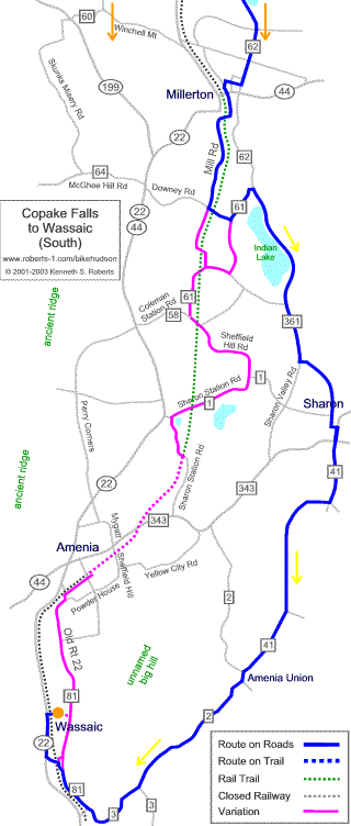
Map Format |
|
|||||||||||||||||||||||||||||||
|
back to Top |
Description | Cue Sheet | Reports | Photos | more routes | About this Map |
|||||||||||||||||||||||||||||||
|
||||||||||||||||||||||||||||||||
|
||||||||||||||||||||||||||||||||
|
|
||||||||||||||||||||||||||||||||
|
|
|
|||||||||||||||||||||||||||||||
|
|
|
|
|||||||||||||||||||||||||||||
|
|
|
|
||||||||||||||||||||||||||||||
|
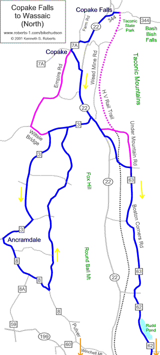
Map Format |
|
|||||||||||||||||||||||||||||||
|
back to Top |
Description | Cue Sheet | Reports | Photos | more routes | About this Map |
|||||||||||||||||||||||||||||||
|
||||||||||||||||||||||||||||||||