|
|||||||||||||||||||||||||||||
 |
|||||||||||||||||||||||||||||
|
|||||||||||||||||||||||||||||
|
|||||||||||||||||||||||||||||
|
|||||||||||||||||||||||||||||
|
|||||||||||||||||||||||||||||
![]()
![]()
![]()
![]()
![]()
Try other map resolutions for viewing and
printing:
[ Printing ] . . .
[ Large resolution ]
digital mapping resources + GPS . . .
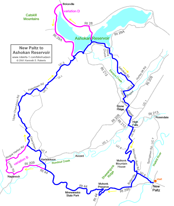
A) New Paltz to Ashokan Res [bhvw7a]: map on Bikely | Google Earth KML | download GPX
B) Ashokan Res to New Paltz [bhvw7b]: map on Bikely | Google Earth KML | download GPX
variation D) Boiceville loop [bhvw7d]: Google Earth KML | download GPX
+ (non-digital) overview map
(see also digital maps of similar
routes set up by other riders -- not checked by us:
. . . [
beelzebub on Bikely |
jeanputzer on MapMyRide |
roadiegirl on MapMyRide ]
Route not checked by us since 2009 -- learn more | see Reports
Description | Cue Sheet | Reports | Photos | About this Map
|
|
|
Home |
Routes
| Main Map | Find
Partners | Discuss | Contact Us
|
|
|
To send us questions or comments about this website, see the contact information -- -- Homepage is www.roberts-1.com/bikehudson |
|
|
© Copyright 1999-2002 Kenneth S. Roberts. Terms of Use |
|