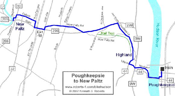
Connecting between

Poughkeepsie and New Paltz

Overall Description of Route
Map of Route
Route Directions Cue Sheet
Trip Reports and Road Condition Reports
more routes
  • 11-12 miles one-way.  Moderate hilliness.

  • purpose:  This route provides some ideas for how to access the New Paltz - Wallkill Valley routes from the nearest railroad station.

  • The Poughkeepsie train station has service by Metro North and Amtrak (as of 2009).

info on New Paltz info on Poughkeepsie train info Mid-Hudson Bridge info Lloyd-Highland Rail Trail info detail map of Poughkeepsie bicycling   

Overall Description of Route Map of Route Route Directions Cue Sheet Trip Reports and Road Condition Reports More Routes

 About this Map

Try different map resolutions for viewing and printing:  
[ Main Overview ] - [ Printing ] - [ Large resolution ]

digital mapping resources + GPS . . .

A) Poughkeepsie to New Paltz [bhve14a]: on Bikely | Google Earth KML | GPX

B) New Paltz to Poughkeepsie [bhve14b] : on Bikely | Google Earth KML | GPX

Description | Map - Pok | Cue sheet: W-bound : E-bound | Reports | More routes

 | About this Map

Home | Routes | Main Map | Find Partners | Discuss | Contact Us
Where to Look | News | Exploring | FAQ | About Us | more

To send us questions or comments about this website, see the contact information -- -- Homepage is www.roberts-1.com/bikehudson

 © Copyright 1999-2002 Kenneth S. Roberts.  Terms of Use