|
or 61 miles, if you combine this with
GWB
to Nyack. Then it becomes the
Manhattan
to Nyack route (with the Fort Lee, NJ start).


It can also be combined it with other routes and variations that
start at the GWB, such as NYC
to Bear Mountain Adventure.
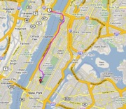
A) GWB to Central Park [bhvn2a]:
view map |
on Bikely |
Google Earth KML
| download GPX
B) Central Park to GWB [bhvn2b]:
view map |
on Bikely |
Google Earth KML |
download GPX
-
highlights: Great views crossing the bridge and cruising along the Hudson, the rollers and curves of the Central Park road,
the cultural sights of Morningside Heights.
-
characteristics: gentle-to-moderate -- more hills
than other parts of Manhattan Island.
Hill climbs: Total climbing about 700 vertical
feet. Two climbs around 100 feet, one with a section at about
10% grade.
Downhills: At least one downhill with a section around
10% grade.
Traffic: Urban motor vehicle traffic. But also to be
taken seriously is the human traffic on the Central Park loop -- the risk of collisions with rollerbladers, runners, oblivious
walkers -- and other bicyclists.
Check
NYC Road Conditions and
GWB Bridge Conditions
And it might have
been a longer time since some of the Variations of the route were last checked by
us. Some roads and intersections might be different since then, or closed
-- so be
prepared to find alternatives -- a good reason to carry a detailed map.
Other people may have more recent experiences with parts of the route which
could help prepare: see the Reports page linked below.
Route not checked by us since 2003 --
learn more |
see
Reports
back to Top | Cue
Sheet | more NYC routes
| Manhattan to Nyack | Getting Around in NYC
more . . .
- directions to Start point in Fort Lee, NJ:
 |
|
To get to the West end of the south walkway of the
George Washington Bridge at Hudson Terrace / Route 505 in Fort Lee,
New Jersey.
From New Jersey by car:
Starting from NJ Turnpike,
I-95 Northbound, or I-80 Eastbound: Get into the Local lanes of the George
Washington Bridge approach. Keep
working into the Right-hand lanes. Exit on the Right at the "last exit in New
Jersey" (last time we were there, it said Rt 67 / Lemoine Ave). At
the end of the exit ramp, continue straight (becomes Bridge Plaza
South) -- avoid left turn onto Lemoine Ave. Then continue straight East to Route
505 / Hudson Terrace,
and find parking -- some possibilities to consider are on Hudson
Terrace (north under the GWB roadway) or in Fort Lee Historical Park
(south of GWB).
From New Jersey by bike: See these pages for some ideas:
Warning: Getting there riding on a bicycle may
require more capability in handling vehicle traffic interaction than the route
itself, with more risks and dangers than the route itself.
From Manhattan by bike: Check the New York City Bike Map at
some of these websites -- can also
purchase a nice paper copy. See also these pages for ideas:
Warning: Getting there riding on a bicycle may
require more capability in handling vehicle traffic interaction than the route
itself, with more risks and dangers than the route itself.
|
|
|
Alternate start point: Central Park (or many
points along the way between Central Park and the GWB). For getting to
the start in Central Park, see the
Central
Park loop description.
back to Top | Cue
Sheet | more NYC routes
| Manhattan to Nyack | Getting Around in NYC
|